👉 The slide deck for this talk → [ Ссылка ]
🛰️ More about the 2023 Geo for Good Summit → [ Ссылка ]
❤️🌍 DESCRIPTION:
During this session, you'll hear 10 lightning talks featuring topics around humanitarian relief, equity, inclusion and social impact related to climate and environment.
💻 TIMESTAMPS:
0:00 - Welcome to Lightning Talks
1:44 - Navajo Nation Earth Observations
7:45 - SIKU: Indigenous Environmental Monitoring
13:24 - Geoscience Insights with Ronadh Cox
19:45 - Remote Sensing Analysis by Jamon Van Den Hoek
25:57 - Rohingya Youth Migration Stories
33:40 - SAR Imagery for Damage Detection
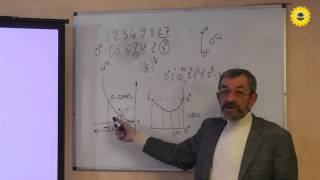
40:03 - Ujaval Gandhi on Earth Engine Charts
45:58 - Tyler Erickson on Earth Engine Community
52:40 - Lightning Talks Q&A Session
55:35 - Software Funding and Maintenance Discussion
1:00:24 - Concluding Lightning Talks
🎙️ SPEAKERS:
- Nikki Tulley, NASA Indigenous Peoples Initiative, BAERI/NASA Ames Research Center, “Nihimá Nahasdzáán – An Indigenous Community Earth Observation Event”
- Becky Segal, Arctic Eider Society, “Mobilizing Earth Engine through SIKU: The Indigenous Knowledge Social Network, an operational platform serving maps in support of Indigenous-led environmental stewardship”
- Rónadh Cox, Williams College, “Mapping interdisciplinarity for environmental justice: analysis of historical documents and land-loss mapping supports a Louisiana tribe's petition for federal acknowledgment”
- Michelle Stuhlmacher, DePaul University, “Earth Observation Data Integration for Environmental Justice and Green Space Equity”
- Jamon Van Den Hoek, Oregon State University, “Mapping Displaced Populations during the Tigray War with Google Earth Engine”
- Robin Al-haddad, DevRA International, “Storytelling and participatory geospatial mapping with Rohingya refugees”
- Ollie Ballinger, University College London, “PIXEL-WISE T-TEST: A new algorithm for persistent building damage detection in synthetic aperture radar imagery”
- Ujaval Gandhi, Spatial Thoughts, “Creating Publication Quality Charts with Earth Engine”
- Tyler Erickson, VorGeo, “Collaboration: Upping your Game”
- Jordi Vera Cartas, Facultad Latinoamericana de Ciencias Sociales (FLACSO), “Google mapping tools in the Mexican unified information system for water and watersheds”