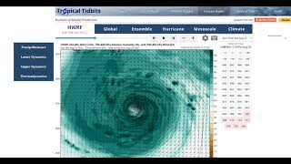
This morning, we continue to closely track Tropical Storm Ida. Ida has intensified and become better organized today, packing winds of 65mph as it moves NW towards Western Cuba. A Hurricane Watch A Hurricane Watch is in effect for Cameron, Louisiana to the Mississippi/Alabama border, Lake Pontchartrain, Lake Maurepas, and Metropolitan New Orleans.
Forecast theory remains largely unchanged. Ida will move northwest towards the Central or Eastern Louisiana coastline, and will be a quickly intensifying and growing hurricane as it approaches. New forecasts show a landfall closer to Sunday night, with models indicating a slow down at the coast now. This extra time over water has prompted forecasts to go up in terms of intensity, with Ida now expected to be a Category 3 hurricane with 120mph winds officially at landfall Sunday night. Honestly, the sky is mostly the limit with this storm, and every preparation should be made for an extreme hurricane.
Early impact ideas include a 7-11 foot storm surge, well over a foot of rain, and wind gusts well north of 100mph. This will be as serious of a strike as they come. Please plan and prepare for such.
---------------------
Redbeard Wx is the YouTube outlet of Redbeard's Weather Page from Facebook. Check us out for all the latest weather information. Ran by a former Weather Marine, the page is dedicated to all things Meteorology, but specializes in Tropical Weather in the Atlantic basin. The page and videos are grounded, honest forecasts, not clickbait hype nonsense. The thoughts expressed are not necessarily the same as official forecast outlets, and should not be solely used in the decision-making process.


